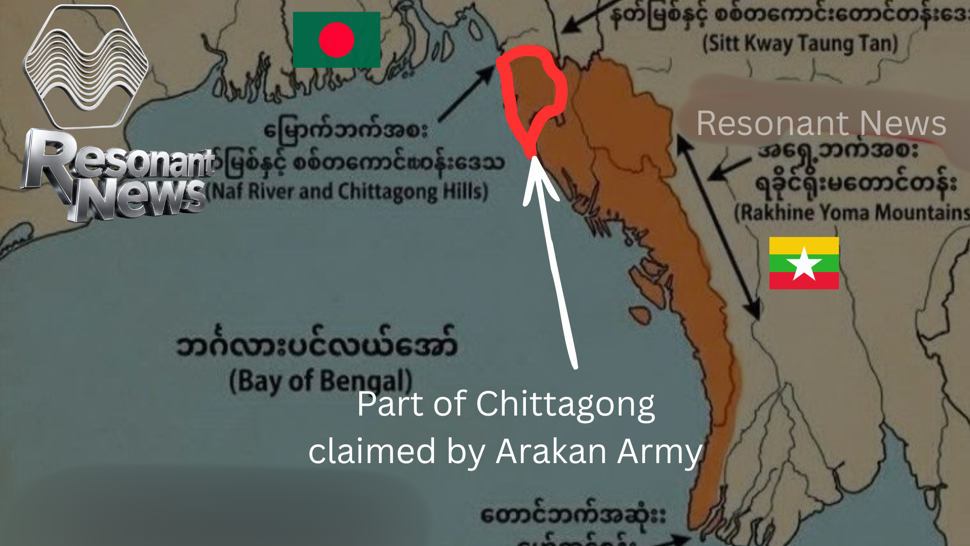

A religious leader of Arakan Army/AA published a controversial map of an independent Rakhine state recently which includes part of Chittagong (Bangladesh).
In a development that has heightened tensions along the Myanmar-Bangladesh border, a religious leader ven U Kandala associated with the Arakan Army (AA) recently published a map depicting an independent Rakhine state (historically known as Arakan) that includes parts of Bangladesh’s Chittagong (Chattogram) region. The map has shocked Bangladeshi public opinion and officials, who view it as a direct challenge to the country’s territorial integrity.
Background on the Arakan Army and Rakhine Conflict
The Arakan Army, a Buddhist-majority ethnic armed organization, has emerged as one of the most effective rebel forces fighting Myanmar’s military junta (Tatmadaw). Operating primarily in Rakhine State, the AA—political wing United League of Arakan (ULA)—seeks greater autonomy or independence for the Rakhine people, drawing on the region’s historical identity as the ancient Arakan Kingdom.
Since launching a major offensive in late 2023 as part of the broader “Operation 1027” resistance against the junta (which seized power in the 2021 coup), the AA has achieved remarkable territorial gains. By late 2024–early 2025, it controlled around 80–90% of Rakhine State, including key border areas with Bangladesh and 14 out of 17 townships. This includes full control of the Myanmar side of the roughly 270-km border, captured notably with the fall of Maungdaw in December 2024.
The group has established de facto administration in many areas, though it faces challenges like governance issues, accusations of forced recruitment (including of Rohingya), and ongoing junta airstrikes.
The Controversial Map and Historical Claims
The map in question, shared via the religious leader’s verified channels, portrays a proposed independent Rakhine/Arakan that extends into Bangladesh’s southeastern “tail” — parts of the Chittagong division. This has been widely circulated on social media and reported in Bangladeshi outlets as an “attack on sovereignty.”
Historically, the Arakan Kingdom (15th–18th centuries) exerted influence over parts of what is now Chittagong and the Chittagong Hill Tracts, a period some Rakhine nationalists reference when discussing “lost territories.” However, such claims have no modern legal basis under international borders established post-independence. Bangladesh has reacted with concern, seeing the map as inflammatory amid already complex border dynamics involving Rohingya refugees, cross-border militants, and security threats.
The AA has repeatedly accused elements within the Bangladeshi and Myanmar militaries of collaborating against it, including claims that Bangladeshi border forces have backed Rohingya insurgent groups like ARSA (Arakan Rohingya Salvation Army) in attacks on AA positions.
These allegations have strained relations, even as Bangladesh engages pragmatically with the AA on issues like potential Rohingya repatriation and humanitarian access.
In April 2026, unconfirmed reports circulated about U.S. officials or military personnel engaging with the AA, adding a layer of international intrigue. While details remain sparse, such contacts (if true) would fit broader patterns of external actors monitoring or influencing Myanmar’s fragmented civil war. China, meanwhile, has its own stakes, particularly in securing Belt and Road projects in the region.
Broader Implications
This map controversy occurs against the backdrop of Myanmar’s ongoing civil war, massive displacement (including over a million Rohingya in Bangladeshi camps), and shifting power dynamics. The AA’s military successes have made it a de facto neighbor to Bangladesh, raising questions about future border management, refugee returns, and potential spillover of conflict.
For Bangladesh, the priorities remain safeguarding sovereignty, managing the Rohingya crisis humanely, and preventing any escalation involving ethnic armed groups or militants operating near the border. The incident underscores how ethnic insurgencies in Myanmar can quickly reverberate across regional boundaries, complicating diplomacy in an already volatile area.
As the AA consolidates control and eyes “final victory” in Rakhine by 2027, maps like this—whether symbolic, provocative, or aspirational—highlight the deep historical grievances and nationalist ambitions fueling the conflict. Bangladesh and the international community will likely watch developments closely to prevent further destabilization.

Leave a Reply